By: Adrienne Marino and Jill Kostel
Effective communication is essential to advancing the adoption of agricultural conservation practices. One powerful tool that supports these efforts is the Agricultural Conservation Planning Framework (ACPF)—a science-based, data-driven approach to watershed planning that helps stakeholders visualize conservation opportunities and better understand the landscape. Recent and current ISAP efforts are utilizing ACPF tools, and ISAP members and other partners are working to expand their use in watersheds throughout Illinois.
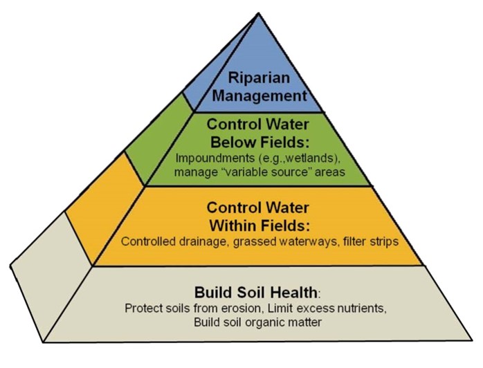
The Agricultural Conservation Planning Framework was developed based on the conservation pyramid. Good soil conservation and nutrient management provide the foundation of effective ag water management – well-managed soils exhibit lower levels of runoff and leaching, improves production. Additional practices are used to manage water within and below fields, and at the stream edge. (ACPF National Hub – https://acpf4watersheds.org)
Understanding ACPF Output Maps
The ACPF leverages high-resolution data on elevation, soils, and land use, combined with a suite of ArcGIS tools, to identify suitable locations for a wide range of conservation practices that can improve water quality. Originally developed by the USDA Agricultural Research Service in collaboration with the Natural Resources Conservation Service (NRCS), the ACPF is now maintained by the ACPF National Hub at Iowa State University.
The Need for Conservation Practices
In Illinois and across the Mississippi River Basin, states are working toward ambitious nutrient reduction goals outlined in their respective Nutrient Loss Reduction Strategies (NLRS). Illinois’ strategy calls for a 45% reduction in nitrogen and phosphorus losses from urban, agricultural, and stormwater sources. In the agricultural sector, achieving these nutrient loss reductions will require widespread, voluntary adoption of conservation practices. The ACPF can help identify suitable locations to focus these efforts.
Engaging Stakeholders with ACPF Maps
ACPF maps can be a powerful asset in stakeholder engagement. Not intended to be prescriptive, they are designed to spark dialogue—highlighting potential opportunities and serving as a starting point for meaningful conversations with farmers and landowners.
Here are five ways ACPF tools can enhance conservation conversations:
- Visualizing the Landscape
ACPF maps translate complex data into intuitive visuals, helping stakeholders quickly grasp watershed dynamics and identify priority areas for conservation. - Educating and Informing
These maps serve as effective educational tools, illustrating how conservation practices contribute to water quality improvements and empowering stakeholders to make informed decisions. - Personalizing Outreach
In one-on-one settings, ACPF maps allow conservation professionals to tailor recommendations to individual landowners—demonstrating how specific practices align with their land and goals. - Facilitating Collaborative Planning
In group discussions, ACPF maps help align diverse stakeholders—farmers, landowners, and conservationists—around shared goals and coordinated strategies for watershed-scale impact. - Recognizing Conservation Success
ACPF maps can also highlight existing conservation efforts, offering an opportunity to recognize and celebrate landowners who are already making a difference—encouraging others to follow suit.
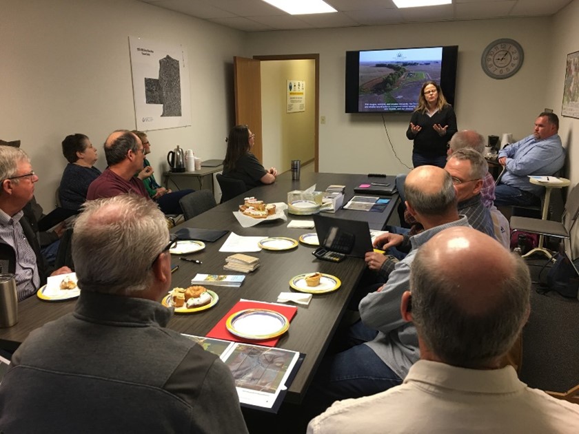
The Wetlands Initiative meets with farmers and landowners in Central Illinois to share ACPF outputs and discuss opportunities for wetlands and other conservation practices. These outputs can also be used to inform landowner conversations in the field.
ACPF Applications in Illinois Watersheds
Watershed Education
ACPF outputs were developed to highlight potential conservation opportunities for Soil and Water Conservation District (SWCD) staff and landowners in Ogle County who are deeply invested in protecting a local stream and preserving the watershed’s rural character. These maps serve as a foundation for education and engagement, helping stakeholders visualize how targeted practices can support long-term watershed health.
Watershed Planning
ACPF tools played a key role in the development of the Vermilion Headwaters Watershed Plan. By evaluating conservation practice placement and estimating nutrient removal potential across 13 sub-watersheds, the planning team was able to align strategies with local sediment and nitrogen reduction goals—ensuring that conservation investments are both effective and measurable.
Targeted Outreach
In Knox County, ACPF outputs are guiding outreach efforts for conservation drainage practices that will be implemented through the Illinois Sustainable Ag Partnership’s (ISAP) Batch & Build Pilot. These maps help identify priority areas for practice installation, enabling more efficient and impactful engagement with landowners.
Expanding Access to ACPF Tools
One of the primary barriers to broader ACPF adoption is the need for access to ArcGIS software and technical expertise. To address this, the Illinois NRCS and the Illinois State Water Survey (ISWS) partnered to streamline access by completing the most technically demanding ACPF steps for several watersheds across the state.
Once these foundational steps are completed and verified, local partners and users with less advanced GIS experience can more easily finish the remaining steps—or contract out the work at a significantly reduced cost. This collaborative approach can help to improve access to ACPF tools and expand their use in watershed planning and conservation outreach.
In closing, ACPF output maps are more than just planning tools—they are conversation starters that can lead to strategic, impactful conservation action. Whether used in group workshops or individual consultations, these maps provide the visual clarity and context needed to foster collaboration and drive progress toward nutrient reduction goals. Are you interested in discussing an ACPF collaboration with ISAP? Please reach out to hello@ilsustainableag.org.