Illinois Cohort Adopts Planning Framework to Expand Conservation
Illinois Sustainable Ag Partnership convenes cohort of Agricultural Conservation Planning Framework users to advance conservation principles while supporting healthy soils, clean water, and profitable farms.
By: Adrienne Marino, Water Quality Project Manager, The Nature Conservancy
Using ACPF Tools to Meet Water Quality Goals
In our work to build soil health and improve water quality in agricultural watersheds, we know many types of solutions – infield, edge of field, AND downstream; structural AND non-structural; urban AND rural – will be required to make progress toward our goals. The Agricultural Conservation Planning Framework (ACPF) is emerging as a strategy to help conservation professionals understand and communicate the range of possible options available to landowners. ACPF integrates high resolution geo-spatial data with a powerful set of analysis tools that allows practitioners to be strategic in their soil and water conservation efforts.
Maps which show potential suitable locations of conservation practices such as grassed waterways, buffers and filter strips, saturated buffers, bioreactors, and constructed wetlands are key outputs of ACPF models. These maps have been used effectively in hundreds of HUC 12 watersheds in the U.S. Corn Belt to start conversations about the wide variety of conservation options available to individual landowners on their farms. ACPF models can also be used to support targeted outreach in key geographic areas and/or on specific practices. By sharing visual representations of the conservation opportunities, these maps can encourage individuals to consider their own operations in the context of the greater watershed.
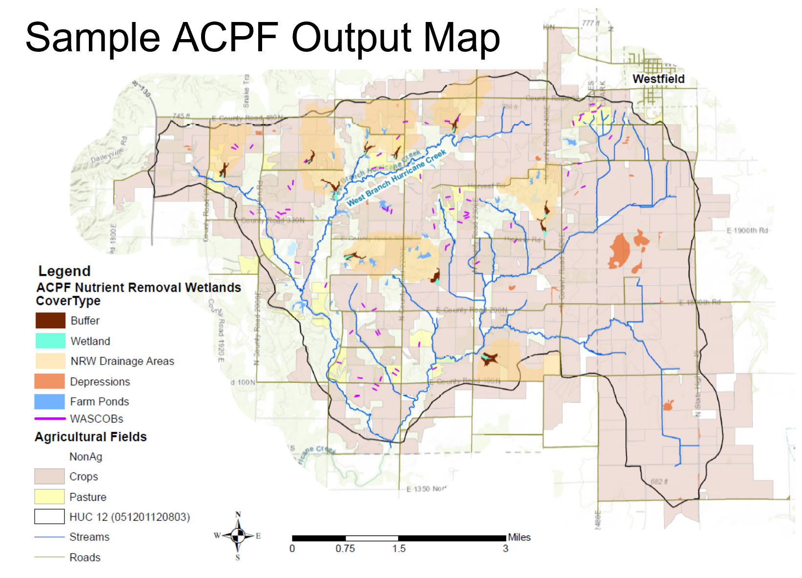
An ACPF output map shows locations that may be suitable, based on GIS analysis, for a range of conservation practices. While these maps display a “menu of available options,” it is important to note that ACPF maps are not prescriptive, that they require verification through field visits or other ground-truthing, and they are one of many tools available to support the conservation planning process.
ACPF in Illinois
Several Illinois Sustainable Ag Partnership (ISAP) member organizations have used or are currently using ACPF to identify potential conservation project locations, guide landowner outreach, and prioritize practice implementation throughout Illinois. As interest in these map-based tools continues to grow within the state and region, there is an opportunity to build ACPF capacity among Illinois users and apply ACPF tools in more watersheds. These efforts can drive conservation planning and outreach efforts in priority watersheds, leading to increased adoption of conservation practices, and creating progress toward the water quality goals outlined in the Nutrient Loss Reduction Strategy (NLRS).
ACPF Training and IL Cohort Formation
To effectively use ACPF, users will need geographic information system (GIS) expertise to run the tool, local knowledge of the watershed to help determine practice preferences and verify results, and stakeholder outreach capacity to deliver the output maps in an appropriate manner to watershed producers and residents. In Fall 2021, several Illinois ACPF users participated in a multi-part regional training that included technical sessions on using the ACPF tools and non-technical sessions on using ACPF outputs in watershed planning and outreach. An Illinois ACPF Cohort formed alongside these regional trainings to provide opportunities for participants to consider how the training topics connect specifically to an Illinois context.
Joining the IL ACPF Cohort
The Illinois ACPF Cohort, coordinated by ISAP, continues to meet to provide opportunities for individuals who are currently using or are interested in using ACPF tools to network with peers, collaborate, troubleshoot, and share lessons learned in an informal space. New members are always welcome to join ACPF cohort meetings which are held approximately bi-monthly. Participating in the Illinois ACPF Cohort may be especially valuable for conservation practitioners interested in new tools for communicating conservation options to producers and landowners, for advisors seeking to connect growers with conservation opportunities for their lower producing acres, and for GIS users interested in expanding their technical skill set.
The next meeting of the Illinois ACPF Cohort will take place on June 14, 2022 at 1pm CT. Click here to access the zoom link for June’s meeting.
Additional information on ACPF, including training materials, are available from the ACPF National Hub (www.acpf4watersheds.org). For more information on the IL ACPF cohort, please reach out to Adrienne Marino (adrienne.marino@tnc.org) or Jill Kostel (jkostel@wetlands-initiative.org).